Tuesday, 29 December 2015

Tahuli / Tavli peak trek via Badlapur side

ताहुली / तावली ,
26/1/2011..and 1/2/2015.
                  Any resident of Badlapur can miss this peak,, most of them dream to climb up it,, likewise being a Badlapur born myself, its been childhood dream to climb up there someday,finally after many yrs of hiking we chose republic day of 2011 to climb it.. will be honest straight away, its not for newbies or ones with poor sense of direction and assessment of how to tackle tough mountains by making own path..now to the actual trek...
                 we took first fast train to BUD from DR, which reaches around 7:45am at BUD. started walking towards Gandhi Chowk,,took turn via Katdare hall to Shivaji Chowk,,bought plenty of vadapaav had tea in a farsan shop there,, later walked till the highway towards those huge water tanks at Shirgaon,,later walked through the road next to water tanks till we were outskirts to human dwelling,, there were many stone quarries around,could hear dynamite going off.. we kept walking till we reached saroli village,and inquired about path to tavli,, they all said there is no path from here till top,, we gave them deaf ears,and asked instead which is furthermost area which u ppl go,so one guy showed us a path,we kept walking for abt 20-25 mins,later reached a small stream,,drank water over there,refilled our reserves,it was by then around 10am.. till this trek was just normal plain walking,,spotted plenty of variety of bulbuls,,snakes,bee eaters,scores of butterflies,etc.. Now comes the tough part..

View of Tahuli from trek path soon after Saroli/savroli village
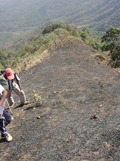
  After getting hydrated at that stream luckily we saw few villagers,probably who lit fire on top of hills adjacent to Tavli,,coming towards us across the stream,,we asked them how to reach top,they too said they had never tried reaching top from this side of the hill,but there is route from Kalyan side,,(of course we know that),,later they showed us a path to take to reach a ridge,which looked possible for us to reach to peak if we kept climbing through it..so we took that path only to find that it was full of thorny plants,highly dense and of huge boulders in between,had to climb trees and through branches onto boulders,took at least 3 hrs for us after lots of acrobats to reach top of the ridge..now new problem arises,,villagers has lit plants on fire on top,, scorching heat from Midnoon sun added to this man made heat,, was boiling hot,our water reserve too got over,unfortunately thats the last time we had water till 9pm at kalyan stn :( ,, now we got over the ridge,it was steep and slippery due to loose mud over it,, steepness takes lots of stamina,and added heat was making it worse,,could hardly walk 5-6 steps,,took 2 more hrs to reach top of the ridge where it connects to bottom of the huge structure of Tavli peak...
 Last water source stream few mins walk from saroli village,,base of tavli 
                                                         Route through the shrubs
                    first glimpe of Taavli structure                              
 Steep climb in the final section

Now, we reached the top rock structure,,it was around 1-2pm already,, we found it was 3 different cylindrical rock formations with huge gap between each of them,rocks were so loose and brittle,even huge ones can be broken down by shear force,,so by a dangerous traverse we reached the last cylindrical rock..
 Ridge walk from top of first hill towards tahuli peaks

View of Badlapur from Tahuli peaks base
 Reached the first cylindrical structure
dangerous traverse begins

 tough route
 beneath the first cylindrical structure


dangerous scree

later we wasted huge time in climbing up the last cylinder directly to reach to main tavli peak.by now it was 4:30pm.. we decided to revert back to traverse and try another route,later we found there was a traverse right till end of the main peak but was even more dangerous,as it had steep slope on one side and wall on another,, somehow we reached other end of it,, finally we saw the route which ppl who live on top of that peak ,use,... we reached to top thinking we would get water up there,,found a dirty tank,with ppl living on top,,we didnt like the quality of it,took few pics,explored and later descended towards kushavali village,, it was 5:30pm already,amazing sunset from top..
 Sunset over Shri Malang
 Ganesh Karthik pinnacle
View of Tahuli from Malang 
After a long walk descending,we reached kushavali village,later took bus to Kalyan stn,, that ends an adventurous trek... i have marked the path we took in Wikimapia u can check that out .
Happy Trekking
"Keep the forts clean,do not litter around,keep trekking commercial free"

Monday, 28 December 2015

Patta / Vishramgad to Aundha / Awandha Trek

विश्रामगढ़ ,
15/1/2012,
                   Another weekend,another trek... this time 2 days we had back to back holidays due to Makara Sankranti,,so we decided to make a 2 day trek.. to gain max power from Sun rays from solstice Sun, and to have a scenic view,, we found Patta fort as the best suited ,calm serene place with no much public at all visiting,unlike other forts which are unfortunately ruined by trekkers with no civic sense..Me,Madhav,Shrikanth and Shashikanth were all set for the trek.
                 We took Tapovan express from Mumbai till Igatpuri,we reached IGP around 8:30-9:00am,,we had breakfast at stn itself, and headed for IGP ST stand nearby,, we took bus around 10-10:30am for Taked village,,reached the base around 11-11:30am and started to walk towards the Patta fort.. many villages came in between,later one villager told us there is a short cut to reach till top plateau instead of taking the tar road route which is way too long and tiring.. the route was between 8 and 9th windmill from the right side when counted,,visibly both windmills are bit extra spaced than others..it was a naal type of route in the ending part and normal ascend trail in its starting section.. keep asking villagers for that short cut..
               We then reached the plateau around 3pm.. had fruits and some light food,,and walked through the tar road till Konkanwadi..later found the route to climb upwards behind the village,,its very easy plain trail route,,while ascending,atleast 100-200 cattle were descending from the fort side,, Cattle were too scared to pass us and there was a standoff between us and them,,we later climbed a rock adjacent to the trail route,then one cattle dared to pass us,and seeing it rest followed ,,atleast 15-20 mins got lost for that unscheduled siding we were put into.. we later reached fort top by 5:30pm,, immediately collected firewood for dinner,smoked the out side area of the cave,as inside it was too dirty with cattle dung,,had nice dinner and went to sleep..
               Got up early next day,had yoga session on Rising Sun of Sankranti day as background,,nice cool windy weather,,by 9am we wound off things,,explored the fort,took snaps from the peak and left for Aundha..by 1pm we had descended the patta fort from a broken Darwaja route which is big shortcut for going towards aundha,,other route going via Pattawadi takes lots of time..
              Total exposure to sun was tiring,,we used to rest beneath the windmill one after the other,finally around 3 pm we reached aundha fort.. we climbed as much we could,as all were tired and time running out,,we later as usual used standard formula for shortest route i.e straight line,,we directly descended the fort through huge rocky slope and reach a small village(not aundhawadi!) on the cliff side of the plateau.. they showed us the path of how to reach Ninavi in shortest time,,,we reached ninavi around 5pm..later luckily we got a tempo going highway side,and reached the highway(ghoti-sinnar road)..we ate something there from dhaba,later hitched hikes transport bus going towards Mumbai from Shirdi side,,we reached Mumbaiby 11pm, by midnight all were home..that ended our trek..

Summary of the trek:-

Maps,imp. pics of the trek:-


                                                  Route from Taked to Patta fort.
                                               Route from Patta to Aundha fort
                                                          Route of Aundha to Ninavi
                                   View of a windmill from shortcut route to patta from taked
                                                                          dinner!
                                                    Dinner for Mavlas after a tiring hike
                                                                Good morning

Happy Trekking
"Keep the forts clean,do not litter around,keep trekking commercial free"


Wednesday, 23 December 2015

Rohidas Trek

                                          Rohidas as seen from Waghachi wadi village.
रोहिदास ,
20/12/2015.
     Least visited fort of Sahyadris undoubtedly though being so close to famous forts around it and famous Malshej ghat nearby.. We planned all of the sudden as winter had approached nicely,so Hemant contacted sable mama at Thitbi village for guiding us through the path till top.,fixed our date as 20,dec 2015,, and kept Kalyan ST stand as meeting spot... Took last ST passing through Malshej ghat,which is around 12:30am at the stand heading for Ahmednagar..
   We reached Savarne village around 3 am,and started to walk towards Thitbi via tar road. reach thitbi in around 20-25 mins,and slept out side Sable mama's house,,which is first house on the left as soon as u enter the village.. we decided to get up by 6am,and start the trek by 6:30am,,so we had less than 1.5hrs to sleep,, village cocks kept on snoozing right from the time we slept,,couple of dog sleepers found hard to sleep,,we got up at 6 am sharp,, and tried out our new ready made breakfast of MTR poha,,which is very easy to prep.. just add hot water to the mixture.. and done.... we later had black tea,and as sable mama was unavailable, his relative fixed us with a guide from another village on path named Waghachi wadi..
   Most surprising pleasant news was only once a year those villagers go to the top of the fort for performing puja at the peak in a temple meant for Kaalbhairav,,and the day we were hiking was that very day!.Felt like Kaalbhairav himself wanted us as special guest from city side!
   We started to hike around 7:15am from that village,around 1 km+ route is pure cake walk through normal clear trail path.. we reached the rohidas naal around 7:45am,and now starts the real bone tiring trek....
   we started to walk from the naal path,and target was to reach topmost part of the naal. after 2 hrs of high acrobatics ,bouldering ,climbing through huge rocks, traversing through sides of the naal with scree on one side,,we reached 25% of the desired target of the naal... saw lots of spiders,rare birds which we couldn't identify by their calls,few common ones like paradise flycatchers,bee eaters,drongos,etc.. saw plenty of giant forest spiders ,signature spiders etc who usually make webs right across the path we walk at our face level,,,careless on path would mean them sticking to ones face :D ,,we noted the region where these spider webs were in maximum,as it would be dark while we would return through the same path..after around 2 hrs from base waghachiwadi,we reached a spot on the naal where water was available.filled up our bottles , drank rested for few mins and started the hike.. this was the last spot where we get water,ahead there is no source for water at all,not even a small stream..
     As we reached 50% of the naal,huge boulders on the path made our speed reduce and was very tiring,boulders kept on coming for atleast 1 hr more,, later when abt 75-80% of naal got covered ,we traversed on left side(beneath rohidas side),and now new hurdles of karvandha tree and another thorny bush started to trouble,,as there is no route,the villagers who went to the top has freshly cut through the path,yet the terrain of slippery mud,occasional dangerous traverse through slippery route with naal on one side made us worry how it would be while descending.
    Soon around 11:30am that naal ended.. we sat at a spot from where naalichi vaat of Hgad was visible,,even large part of KK was visible,,lingi pinnacle was just stone's throw distance away from us across the gap(kol) between both forts,,after resting for few mins and taking few snaps,we started walking again..
    Route becomes more difficult now,body tired, Sun on top,hunger ,muscle fatigue makes things worse..few traverses and we reach a small plateau,and then to a spot where villagers left their bags,slippers etc behind and headed for the peak..from that spot again climbing began with even more dangerous small rock patches,slippery trail,and lots of acrobats,we reached the topmost small plateau,we left our bags behind at a spot,and went from the last 30 mins ascend.the path narrowed down in the end,both side scree ,with same kind of slippery route,,fragrance of karvi plant's flower buds all around,we finally were few meters away from the peak.. just about few feet before the peak there is a quite a big gap in between the path ,,we have to jump across it,,it was like the snake in snakes and ladder game at 99,which would send u back to square one,,after crossing that gap,we finally reached the peak,,its very small peak,hardly few feet across,with small makeshift kind of temple for kaalbhairav on top.. view of Hgad was amazing from the top. we spent few mins on top clicking pics,and performed prayers too for kaalbhairav as it was special day for the temple too.. Time was around 2:15pm when we started to descend .
      Reached to the spot where we had left our bags,, had lunch,and started to walk ,it was nearing 3pm,, we reached the plateau where the villagers leave their slippers etc, and spotted sambar deer,we had seen its scats on the path,and also spotted civet cat scats in same area.. clean serene place away from filth of western civilization becoz of least number of people visiting that place.
    we reached the kol around 4pm,and was getting dark already as the naal is surrounded by high mountains, after a long walk through the jungle,we reached the naal around 5pm. fatigue,tired legs,cramps due to dehydration could be felt,,kept dragging till we reached the water source spot,, it was at 50% distance of the naal,rested there for many minutes,filled up bottles,became fresh and started to descend again,time was around 6:30-7pm, fully dark,with torch lights and head lamps rest of the trek was finished,,we reached waghachiwadi and the guide left us,, and we reached thitbi by 9:15pm late by 1 hour. due to the day being sunday,and non availability of convenient buses from savarne to kalyan,we decided to stay at thitbi itself for the night,we had poha and dal rice and slept till next day 6am,later after getting fresh,we took truck which ferried all villagers going to savarne. we got bus around 7 am from savarne till kalyan,,reached kalyan st stand by 9:15,that ended our trek..
IMPORTANT:-,, this trek is not meant for beginners,with less than 15-20 trek exp. it requires high endurance and many places have very dangerous path,, plz make note of this.. good luck
Happy Trekking.

Summary of the trek:-
Maps,Imp. pics of the trek:-
                                                              Kaalbhairav and me
                                                       Naal which we walked
                                                             Hood of konkankada
                                                                       Naal route
                                                              Only source of water
                                                     highly acrobatic route,,very tough
                                                                      Lingi pinnacle
                                                        entire view of naalichi vaat Hgad
                                                                     Civet cat scat
                                                            Taramati and kokankada
                                                                Kaalbhairav temple

 Huge gap just few feet from the peak,,highly dangerous,,as i mentioned in the blog,,its like snake at 99 which would send u to 0 in the game of snakes and ladders.
                                                                         The route
Things to be taken care of:-
    Trek is very very difficult,,very tiring,the worst ever in my experience... its total of 14 hrs trek. 7 hrs to climb,7 hrs to descend back to village.. so plan accordingly.. guide is must.. there is no open route as hardly anyone hikes there.. carry minimum 4 liters of water,and wear good shoes and socks,,as i personally first time experienced blister on both the foot sole which delayed our target of 14 hrs to 15 hrs...some traverses are very dangerous,,we didnt use ropes but u may require.. there are minimum 10-15 such traverses.. there is no water once u cross the middle of naal.. no shady place also,,so best time is peak of winter.. monsoons dont even imagine going there.
"Keep the forts clean,do not litter around,keep trekking commercial free"

Monday, 21 December 2015

Irshalgad to Prabhal machi via ridge trek..

Irshalgad-Prabhalgad,
Feb,2012,
                Irshal Prabhal Kalvantin form a cluster of forts for hiking in that region,, we planned to connect Irshalgad trek to Prabhal machi as just irshal trek was too easy...
               Me,Ajit,Madhav,and Shashikanth were free for the day,,so all of us planned for it,,..
 We took last train for karjat which reached KJT around 3 am... rested at karjat ST stand for the night.. After few hrs sleep we took first bus going towards panvel side around 6 am.. we got down at Chowk rly stn stop. and with no wasting time,started the trek to reach irshalgad.. we crossed tracks,and after 20-25 mins walk we reached near morbe dam,,walked along its banks,sighting early birds and vegetable plantation on other side,was a nice walk,,we chose a spot where we had dry woods and water from the dam,,,we made our breakfast and tea,,,after munching on noodles and tea,,we had a thought,,why not make the trek bit harder,,as we knew irshal trek is too easy for a trek,,we decided to make our own route till base of irshal .. we wound off our breakfast and rest and took off for irshal.. used the following route to reach irshal as shown on map

                                            our breakfast :)
                           Yellow line is the regular route,, Red line is what we took to make it more thrilling...
  

later we reached the base of irshalgad,,rested for few mins,and then without any waste of time took off for the fort,,after around 1 hr,we reached the top and were confused,,as last time when we had come,,the top part was connected all the way till the end,,but this time we found entire section to be very thin and dangerous with steep fall on both the sides,,,we reverted back and saw another route going from down near the caves which would later rise till top.. we descended and took that route to find that the old caves had disappeared ! entire section from top of the fort had collapsed and closed that caves..later we reached till top of the fort took few pics,tried acrobatics on the small pinnacle on top,saw needhe and then descended the fort towards north east side,,we reached a spot and found route reached to a dead end,! so we walked in wrong direction,,and were too lazy to go back all the way and come around,,although the route seemed to be dead end,but one could descend those huge rocks with few acrobats,,,so we tried it,and it was quite easy,,we saved lots of time and energy due to our dare to try it. check the pic for the route we took

                            Red line is the acrobatic stretch,,yellow is the route we took to descend towards the ridge connecting both forts.

               It was already noon,,so decided to have our lunch,,made sandwich and took a 30 mins nap beneath a tree.. it was 1:30 pm and time for the ridge..following is the pic of the ridge


                 Red line is the path we took from ridge till thakurwadi base of prabhal via machi.

After a long walk around 2 hrs via ridge we reached the machi,,route was pretty straight and easy,spotted lots of birds while we passed near prabhalgad region,,we reached the first house on machi,,they showed another easy short cut to descend the machi than to go across the machi which joins kalavantin route,,it saved nearly 1 hr of us.. we reached the base around 5:30 pm,got a tempo,hitch hiked till panvel stn.. had food at a hotel nearby,,took train and that ended our another beautiful trek.

Any questions,do post it in comments.

Happy Trekking